Located in the far northeast of Morocco, in the Oriental Region, Ahfir is a major border town rich in history. Ideally situated about 19 km from Saïdia, 20 km from Berkane, and 35 km from Oujda, it directly faces the Algerian village of Boukanoune, separated only by the Kiss River (Oued Kiss).
The Origins of the Name and the Context of the Kiss River
Long before becoming a modern urban center, the area where Ahfir stands today belonged to the historical territory of the Amazigh (Berber) confederation of the Beni Snassen.
The word “Ahfir” means “holes” or “trenches” in the Berber language. Two major historical explanations are associated with the origin of this name:
The Mining Theory
According to this version, the name refers directly to an ancient mining quarry that was once operated in this location.
The Military Theory (1859)
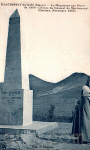
During border conflicts, French General Edmond de Martimprey and his troops entrenched themselves near the Kiss River to protect against local fighters. They fortified their position behind deep trenches known locally as “Ihfren,” leaving a lasting mark on local collective memory.
The Colonial Era: The Birth of Martimprey-du-Kiss
The destiny of Ahfir changed dramatically at the beginning of the twentieth century. What had long been a transit territory became a laboratory for military and urban colonization directed from neighboring Algeria, then under French administration.
The Military Occupation of 1907
Well before the signing of the Treaty of Fez in 1912, which established the French Protectorate over Morocco, the Oriental region was already under pressure from French troops stationed in Algeria. Citing cross-border unrest and insecurity, the colonial army crossed the Kiss River.
On March 29, 1907, General Hubert Lyautey ordered the occupation of Oujda and deployed troops along the border. At that moment, the strategic site of Ahfir was heavily occupied by military detachments.
The 1908 Decree and the Tribute to Martimprey
In 1908, Lyautey formalized this occupation by establishing a military post and a colonial settlement officially named Martimprey-du-Kiss.
The name was chosen in honor of General Edmond de Martimprey, who had distinguished himself in the region during the Tafna expedition of 1859 against Moroccan resistance fighters.
From Military Outpost to Commercial Crossroads
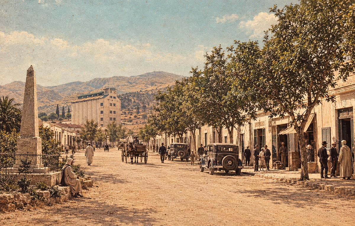
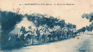
The city’s original urban design followed a strictly military logic: broad straight avenues to facilitate troop movements, fortified barracks, and observation posts facing the border and the Beni Snassen Mountains.
However, geography soon reshaped its destiny. Located between the fertile Triffa plains and the crossroads linking Oujda to the Mediterranean coast (Saïdia), the military post gradually transformed into a key commercial center.
Lyautey encouraged merchants to settle in the town. Ahfir’s market quickly became one of the most important in the region, where mountain tribes exchanged cereals, livestock, and handicrafts for imported manufactured goods.
A Historical Model of Coexistence
Although Martimprey-du-Kiss was born out of military confrontation, its social composition during the first half of the twentieth century gave rise to a unique cosmopolitan micro-society characterized by tolerance and constant interaction among diverse communities.
The Human Mosaic of Ahfir
For nearly fifty years, the city was shaped by four main demographic groups:
• Local Moroccans: Primarily Beni Snassen Berbers and Arabic-speaking populations from the plains, who formed the agricultural and commercial backbone of the city.
• Algerians from Orania: Originating from Tlemcen, Bab El Assa, and Nedroma, they brought artisanal skills, Gharnati musical traditions, and often maintained close family ties with the inhabitants of Ahfir.
• The Moroccan Jewish Community: Highly active in trade, textile craftsmanship, goldsmithing, and wholesale commerce, they represented an essential pillar of the urban economy.
• Europeans: Mainly French, but also many Spaniards and Italians from Algeria and the neighboring Spanish Protectorate areas such as Melilla and Nador. They occupied administrative positions, managed modern infrastructure, and operated agricultural lands in the Triffa plain.
Everyday Harmony
Coexistence went beyond simple tolerance and was reflected in daily life and local traditions.
Languages mixed freely: Beni Snassen Berber, local Arabic influenced by Oranian expressions, French used by the administration, and Spanish spoken by traders.
Religious celebrations were respected by all communities, while children of different faiths shared the same playgrounds and streets in the colonial town center.
The Enduring Testimony of the Three Cemeteries
Perhaps the most moving symbol of this period is the historical presence of three distinct religious cemeteries in Ahfir: the Muslim cemetery, the Jewish cemetery, and the Christian cemetery.
Built during the same era, these cemeteries bear witness to the fact that these communities not only lived side by side but also rooted their memories and ancestors in the same land. Even today, although the demographic composition of the city has changed profoundly since 1956, these sites continue to be respected as guardians of a shared historical heritage.
Demographic Evolution and Colonial Statistics
At the time of its foundation, Martimprey-du-Kiss was merely a modest military outpost surrounded by a few settlers’ homes and merchants’ establishments. However, the site’s economic attractiveness soon led to significant population growth.
Population Structure
Colonial censuses generally divided the population into two administratively distinct categories:
• The “native” population, including Moroccans and cross-border Algerians.
• The “European” population, including French, Spanish, and Italian residents.
Population Proportions
Although the town was established by and for the colonial administration, the Moroccan population, mainly originating from the Beni Snassen tribes, remained largely dominant, generally representing between 75% and 85% of the total population throughout the colonial period.
The European Community
Its population reached its peak during the 1930s and 1940s, numbering several hundred permanent residents. Most were customs officials, military personnel, railway workers connected to the regional railway network, and large landowners operating agricultural estates in the Triffa plain.
The Jewish Community
Although no specific statistical records are readily available for Ahfir alone, regional archives indicate that the Jewish community constituted an active and influential part of the urban commercial fabric through its involvement in shops, textile trade, and jewelry craftsmanship.
Life in Martimprey-du-Kiss
Daily life in Martimprey-du-Kiss revolved around the border, agriculture, and trade. The town functioned as a vibrant bridge between French Algeria and Protectorate Morocco.
The Beating Heart: The Monday and Thursday Souk
Local life was closely linked to market days. Historical accounts indicate that the main market was traditionally held twice a week, on Mondays and Thursdays.
It was a major regional event where people from the Beni Snassen mountains came to sell olives, citrus fruits, almonds, and livestock. In return, they purchased textiles and manufactured goods imported from Europe or transiting through Algeria.
The Influence of Neighboring Orania
Due to its immediate proximity to Bab El Assa and the Tlemcen region, life in Martimprey-du-Kiss was deeply influenced by the culture of western Algeria.
Food and Customs
Families on both sides of the Kiss River shared similar culinary traditions, clothing styles, and cultural practices.
Linguistic Transition
It was during this period that the local Berber-speaking population of Beni Snassen became increasingly Arabic-speaking. The dialect spoken in Martimprey adopted many expressions, accents, and linguistic forms characteristic of Oranian Arabic.
Leisure and Social Life
European social life revolved around colonial cafés, the military club, and Christian parish celebrations.
For Moroccan and Algerian residents, social interaction centered on traditional cafés, lively discussions in market squares, and the celebration of regional moussem festivals, combining religious and cultural traditions.
Despite the social barriers imposed by the colonial system, the small size of the town encouraged close human interaction, fostering the atmosphere of peaceful coexistence that remains an important part of Ahfir’s history.
Independence (1956) and the Return to Moroccan Identity
Following Morocco’s independence in 1956, the municipality removed the symbols of colonial rule. The town officially regained its original name: Ahfir.
From that moment onward, the city’s trajectory changed. Once a major and fluid crossing point between Morocco and Algeria, Ahfir experienced the consequences of regional geopolitical tensions, particularly the prolonged closure of the land border between the two countries.
Nevertheless, the city has successfully reinvented itself thanks to its proximity to Oujda-Angads Airport and its role as an economic hub for the surrounding agricultural communities.
Note
This article was prepared largely from the archives of the former Ahfir Europe website, as well as from various historical and documentary sources available on the Internet, including Wikipedia and other specialized websites.
Despite the care taken in its preparation, this article remains open to contributions that may further enrich the history of Ahfir.
If you have comments, testimonies, corrections, historical documents, or additional information about the history of the city of Ahfir, please do not hesitate to participate through the comments section above. Your contribution will help preserve and transmit the collective memory of our city.
Rachid LEGSSYER
Date: 14/10/2026